
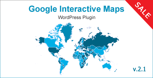
Google Interactive Maps Wordpress Plugin - Rating, Reviews, Demo & Download


Plugin Description
Google Interactive Maps – WordPress Plugin for creating responsive interactive maps.
- Zoom option with mousewheel and/or control button,
- Built-in Modal Popup modal function for click events,
- HTML Tooltip on hover function (can show images in tooltip),
- Included Data,
- Generates SVG Maps (No Flash),
- Based on Google Geochart API
Fully compatible with the latest WordPress 5+ version and Visual Composer (WPBakery Page Builder) plugin!
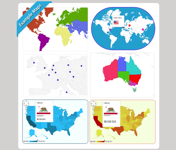
Check some Examples of Google Interactive Maps plugin in action
Google Interactive Maps plugin allows to create more than 300 different responsive maps of
- entire World (divided into countries, continents or subcontinents),
- world Continent (divided into countries or subcontinents),
- world Subcontinent (divided into countries),
- a single Country (whole country or divided into Provinces),
- US State or Metropolitan areas
Active area can be shown in multiple ways: as fully colored Region, Marker with colored bubble, Custom Icon or Custom Logo.
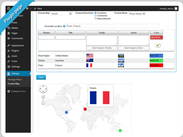
Each active region can have Tooltip on hover and an Action on click. Both tooltip and action values can have HTML formatted text and images.
For each map individually can be set its own
- Width and height,
- Background color,
- Border width and color,
- Border Radius (supported by modern browsers),
- Inactive region color,
- Marker size,
- Zoom possibility,
- Action on click.
Plugin allows to use both shortcodes for posts, pages and widgets, or just insert the code into template. Plugin is based on Google GeoChart API, all necessary country and province data is included. Plugin enables to zoom maps with mouse scroll and drag them.
You can display multiple responsive maps on the same page, or display same maps in different pages.
Plugin includes complete data of Continent Hierarchy and Codes according to Google Visualization Geochart
| Continent | Sub-Continent | Countries |
|---|---|---|
| Northern Africa | Algeria (DZ), Egypt (EG), Western Sahara (EH), Libya (LY), Morocco (MA), Sudan (SD), Tunisia (TN) | |
| Western Africa | Burkina Faso (BF), Benin (BJ), Cote d’Ivoire (CI), Cape Verde (CV), Ghana (GH), Gambia (GM), Guinea (GN), Guinea-Bissau (GW), Liberia (LR), Mali (ML), Mauritania (MR), Niger (NE), Nigeria (NG), Saint Helena, Ascension and Tristan da Cunha (SH), Sierra Leone (SL), Senegal (SN), Togo (TG) | |
| Africa | Middle Africa | Angola (AO), Congo, the Democratic Republic of the (CD), Zaire (ZR), Central African Republic (CF), Congo (CG), Cameroon (CM), Gabon (GA), Equatorial Guinea (GQ), Sao Tome and Principe (ST), Chad (TD) |
| Eastern Africa | Burundi (BI), Djibouti (DJ), Eritrea (ER), Ethiopia (ET), Kenya (KE), Comoros (KM), Madagascar (MG), Mauritius (MU), Malawi (MW), Mozambique (MZ), Reunion (RE), Rwanda (RW), Seychelles (SC), Somalia (SO), Tanzania, United Republic of (TZ), Uganda (UG), Mayotte (YT), Zambia (ZM), Zimbabwe (ZW) | |
| Southern Africa | Botswana (BW), Lesotho (LS), Namibia (NA), Swaziland (SZ), South Africa (ZA) | |
| Northern Europe | Guernsey (GG), Jersey(JE), Aland Islands (AX), Denmark (DK), Estonia (EE), Finland (FI), Faroe Islands (FO), United Kingdom (GB), Ireland (IE), Isle of Man (IM), Iceland (IS), Lithuania (LT), Latvia (LV), Norway (NO), Sweden (SE), Svalbard and Jan Mayen (SJ) | |
| Europe | Western Europe | Austria (AT), Belgium (BE), Switzerland (CH), Germany (DE), France (FR), Liechtenstein (LI), Luxembourg (LU), Monaco (MC), Netherlands (NL) |
| Eastern Europe | Bulgaria (BG), Belarus (BY), Czech Republic (CZ), Hungary (HU), Moldova, Republic of (MD), Poland (PL), Romania (RO), Russian Federation (RU), Slovakia (SK), Ukraine (UA) | |
| Southern Europe | Andorra (AD), Albania (AL), Bosnia and Herzegovina (BA), Spain (ES), Gibraltar (GI), Greece (GR), Croatia (HR), Italy (IT), Montenegro (ME), Macedonia, the former Yugoslav Republic of (MK), Malta (MT), Serbia (RS), Portugal (PT), Slovenia (SI), San Marino (SM), Holy See (Vatican City State) (VA) | |
| Northern America | Bermuda (BM), Canada (CA), Greenland (GL), Saint Pierre and Miquelon (PM), United States (US) | |
| Americas | Caribbean | Antigua and Barbuda (AG), Anguilla (AI), Netherlands Antilles (AN), Aruba (AW), Barbados (BB), Saint Barthelemy (BL), Bahamas (BS), Cuba (CU), Dominica (DM), Dominican Republic (DO), Grenada (GD), Guadeloupe (GP), Haiti (HT), Jamaica (JM), Saint Kitts and Nevis (KN), Cayman Islands (KY), Saint Lucia (LC), Saint Martin (French part) (MF), Martinique (MQ), Montserrat (MS), Puerto Rico (PR), Turks and Caicos Islands (TC), Trinidad and Tobago (TT), Saint Vincent and the Grenadines (VC), Virgin Islands, British (VG), Virgin Islands, U.S. (VI) |
| Central America | Belize (BZ), Costa Rica (CR), Guatemala (GT), Honduras (HN), Mexico (MX), Nicaragua (NI), Panama (PA), El Salvador (SV) | |
| South America | Argentina (AR), Bolivia, Plurinational State of (BO), Brazil (BR), Chile (CL), Colombia (CO), Ecuador (EC), Falkland Islands (Malvinas) (FK), French Guiana (GF), Guyana (GY), Peru (PE), Paraguay (PY), Suriname (SR), Uruguay (UY), Venezuela, Bolivarian Republic of (VE) | |
| Central Asia | Turkmenistan™, Tajikistan (TJ), Kyrgyzstan (KG), Kazakhstan (KZ), Uzbekistan (UZ) | |
| Eastern Asia | China (CN), Hong Kong (HK), Japan (JP), Korea, Democratic People’s Republic of (KP), Korea, Republic of (KR), Mongolia (MN), Macao (MO), Taiwan, Province of China (TW) | |
| Asia | Southern Asia | Afghanistan (AF), Bangladesh (BD), Bhutan (BT), India (IN), Iran, Islamic Republic of (IR), Sri Lanka (LK), Maldives (MV), Nepal (NP), Pakistan (PK) |
| South-Eastern Asia | Brunei Darussalam (BN), Indonesia (ID), Cambodia (KH), Lao People’s Democratic Republic (LA), Myanmar (MM), Burma (BU), Malaysia (MY), Philippines (PH), Singapore (SG), Thailand (TH), Timor-Leste (TL), Viet Nam (VN) | |
| Western Asia | United Arab Emirates (AE), Armenia (AM), Azerbaijan (AZ), Bahrain (BH), Cyprus (CY), Georgia (GE), Israel (IL), Iraq (IQ), Jordan (JO), Kuwait (KW), Lebanon (LB), Oman (OM), Palestine, State of (PS), Qatar (QA), Saudi Arabia (SA), Syrian Arab Republic (SY), Turkey (TR), Yemen (YE) | |
| Australia and New Zealand | Australia (AU), Norfolk Island (NF), New Zealand (NZ) | |
| Oceania | Melanesia | Fiji (FJ), New Caledonia (NC), Papua New Guinea (PG), Solomon Islands (SB), Vanuatu (VU) |
| Micronesia | Micronesia, Federated States of (FM), Guam (GU), Kiribati (KI), Marshall Islands (MH), Northern Mariana Islands (MP), Nauru (NR), Palau (PW) | |
| Polynesia | American Samoa (AS), Cook Islands (CK), Niue (NU), French Polynesia (PF), Pitcairn (PN), Tokelau (TK), Tonga (TO), Tuvalu (TV), Wallis and Futuna (WF), Samoa (WS) |
Each country has its regions/states predefined data.
For example
United States
Alaska, Alabama, Arkansas, Arizona, California, Colorado, Connecticut, District of Columbia, Delaware, Florida, Georgia, Hawaii, Iowa, Idaho, Illinois, Indiana, Kansas, Kentucky, Louisiana, Massachusetts, Maryland, Maine, Michigan, Minnesota, Missouri, Mississippi, Montana, North Carolina, North Dakota, Nebraska, New Hampshire, New Jersey, New Mexico, Nevada, New York, Ohio, Oklahoma, Oregon, Pennsylvania, Rhode Island, South Carolina, South Dakota, Tennessee, Texas, Utah, Virginia, Vermont, Washington, Wisconsin, West Virginia, Wyoming
United Kingdom
England, Northern Ireland, Scotland, Wales
Australia
Australian Capital Territory, New South Wales, Northern Territory, Queensland, South Australia, Tasmania, Victoria, Western Australia
Canada
Alberta, British Columbia, Manitoba, New Brunswick, Newfoundland and Labrador, Nova Scotia, Northwest Territories, Nunavut, Ontario, Prince Edward Island, Quebec, Saskatchewan, Yukon Territory
Germany
Brandenburg, Berlin, Baden-Wurttemberg, Bayern, Bremen, Hessen, Hamburg, Mecklenburg-Vorpommern, Niedersachsen, Nordrhein-Westfalen, Rheinland-Pfalz, Schleswig-Holstein, Saarland, Sachsen, Sachsen-Anhalt, Thuringen
France
Alsace, Aquitaine, Auvergne, Bourgogne, Bretagne, Centre, Champagne-Ardenne, Corse, Franche-Comte, Ile-de-France, Languedoc-Roussillon, Limousin, Lorraine, Midi-Pyrenees, Nord-Pas-de-Calais, Basse-Normandie, Haute-Normandie, Pays de la Loire, Picardie, Poitou-Charentes, Provence-Alpes-Cote d’Azur, Rhone-Alpes
Spain
Andalucia, Aragon, Asturias, Principado de, Cantabria, Castilla y Leon, Castilla-La Mancha, Canarias, Catalunya (ca) [Cataluna], Extremadura, Galicia (gl) [Galicia], Illes Balears (ca) [Islas Baleares], Murcia, Region de, Madrid, Comunidad de, Navarra, Comunidad Foral de, Pais Vasco / Euskadi (eu), La Rioja, Valenciana, Comunidad
Greece
Anatoliki Makedonia kai Thraki, Kentriki Makedonia, Dytiki Makedonia, Ipeiros, Thessalia, Ionia Nisia, Dytiki Ellada, Sterea Ellada, Attiki, Peloponnisos, Voreio Aigaio, Notio Aigaio, Kriti
Japan
Hokkaido [Hokkaido], Aomori, Iwate, Miyagi, Akita, Yamagata, Hukusima [Fukushima], Ibaraki, Totigi [Tochigi], Gunma, Saitama, Tiba [Chiba], Tokyo [Tokyo], Kanagawa, Niigata, Toyama, Isikawa [Ishikawa], Hukui [Fukui], Yamanasi [Yamanashi], Nagano, Gihu [Gifu], Sizuoka [Shizuoka], Aiti [Aichi], Mie, Siga [Shiga], Kyoto [Kyoto], Osaka [Osaka], Hyogo [Hyogo], Nara, Wakayama, Tottori, Simane [Shimane], Okayama, Hirosima [Hiroshima], Yamaguti [Yamaguchi], Tokusima [Tokushima], Kagawa, Ehime, Koti [Kochi], Hukuoka [Fukuoka], Saga, Nagasaki, Kumamoto, Oita [Oita], Miyazaki, Kagosima [Kagoshima], Okinawa
And all other countries
Testimonials

Changelog
v2.1 - September 16, 2018
* The plugin became Visual Composer Ready, a few small improvements and fixes
v2.0 - September 09, 2018
* Global Update - added new options of custom logos, custom icons, a lot of tooltip modifying and other options, modal popup script, other improvements and fixes
v1.5 - December 02, 2016
* Fixed some issues, made some improvements and added a setting field for Geochart API key.
v1.4 - October 09, 2015
* Fixed some issues, added new functions
v1.3.3 - February 27, 2015
* Fixed zoom issue, added new option "Draggable if Zoom Fixed", added support for SSL (https) enabled sites
v1.3.2 - July 30, 2014
* Fixed some bugs with ie9
v1.3.1 - July 12, 2014
* Added background transparency, background image, inactive region transparency, regions border color, regions border width options
v1.3.0 - June 02, 2014
* Added new option "Text labels"
v1.2.1 - May 28, 2014
* Compatibility fix with Visual Composer
v1.2.0 - May 21, 2014
* Added new function "fixate", small improvements
v1.1.4 - May 10, 2014
* Fixes regarding themes, small improvements
v1.1.3 - April 19, 2014
* Added new self action, updated image upload function, fixed shortcode and province issues
v1.1.2 - April 09, 2014
* New line fixes in datarows
v1.1.1 - April 02, 2014
* Smooth load fixes
v1.1.0 - March 27, 2014
* Added responsivity to maps
v1.0.2 - March 20, 2014
* Some minor bug fixes
v1.0.1 - March 15, 2014
* Bug fix: fixed css style
v1.0 - March 14, 2014
* Initial Release of the plugin