
Google Maps GPX Viewer Wordpress Plugin - Rating, Reviews, Demo & Download

Plugin Description
Demo pages
– GPX file with multiple tracks and POIs
– GPX Viewer, invite your visitors to drag there own gpx or kml on the map
– TourScout, lists all tracks, google placec search
– TourScout Navi App, lists all tracks, google placec search
– GPX & KML files with elevation profile
– Topo maps from foreign countries
– Google Fusion Tables
– Yellow-Pages & Google Places
– Map search with Geocodes
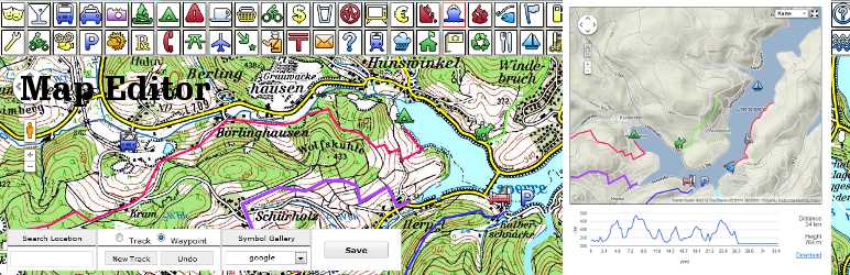
– Track & POI Editor
Description, FAQ, Support blog
This plugin inserts google maps to your posts.
Upload GPS tracks, trails or Points of Interests by gps files like kml or gpx
Create and edit tracks, waypoints and POI’s.
Show an interactive elevation profile and download link on tracks & routes.
Insert Panoramio pictures selected by tags or user ID.
Add address or lat-lon markers with your own image or icon.
In edit mode use the Insert Map Button to place your map or use shortcodes.
Specially adapted for geoportal owner and blogger like cycling, biking, walking, sailing, flying, offroad but usable for travelling, tourist office, car rental and real estate too.
Features:
* GPS files KML or GPX
* GPS Viewer drag KML or GPX on the map
* TourScout
* Map Editor
* Panoramio Pictures
* Elevation Profile on tracks
* Google Fusion Table with query option and auto viewport
* Open Street Map, Open Cycle Map, OSGEO Map
* add unlimited WMS, OSM or OSGEO server
* multiple maps on the same post
* Marker-manager to toggle POIs
Supported ShortCodes
Insert the following shortcode [map option=”value”] into your posts
where option can be:
maptype=OSM values: roadmap, terrain, satellit, hybrid, Relief, OSM, ‘OSM cycle’, WMS
style=”width:300px; height400px; margin:20px” must be css-conform
gpx=”direct or absolute path to the gpx-file”
kml=absolute path to the kml-file
address=”Berlin, Germany” location by geocoded address
lat=”51.093″ lon=”7.23544″ location latitude/longitude
z=”15″ set zoom level (0-20) depends on maptype
marker=”yes” add location marker
infowindow=”text to be published” add Infowindow
markerimage=”URL” add custom marker image
pano=”yes”add images from Panoramio
panotag=”tag/user-id”select Ponoramio images by tag or user ID
traffic=”yes” add traffic layer
bike=”yes” add bicyle layer
fusion=”934502,Location,postcode < 40000″ add google fusion table layer
mtoggle=”yes” markers list to toggle POIs
Screenshots

GPX file with track, waypoints, elevation profile and download link in your post

Map manager to style and configure your map

Option setting page

Track and waypoint editor