Groundwork Common Location Finder Wordpress Plugin - Rating, Reviews, Demo & Download

Plugin Description
Most location finders decide in advance what a location is: a store with a phone
number, or a clinic with services. If your locations do not fit that shape, you
end up storing “Wheelchair accessible” in a field labeled Fax.
This plugin has three built-in fields — name, latitude, longitude — and
nothing else. Every other field is one you define in wp-admin: its type, its
label, whether it shows on the result card or only in the detail pane, whether
it is searchable, whether it becomes a filter. A food bank defines Services and
Eligibility. A clinic defines Specialties and Languages Spoken. Neither pretends
to be the other.
Field types
Nine simple types — text, textarea, URL, email, phone, number, yes/no, select,
multi-select — plus three composites that are genuinely hard to do by hand:
- Address — six subfields, a formatted one-line version, and a directions link.
- Recurring hours — not just “9–5 Monday”, but “2nd and 4th Tuesday, 9am–4pm”.
Consecutive days collapse on display, so seven rows read as “Mon–Fri 9am–5pm”. - Temporary closures — a date range with a reason. While one is active, the
location shows a closure notice and stops reporting itself as open.
What visitors get
A map with pins and a list beside it, on one screen. Type to search; the
typeahead suggests location names, cities, and the values of your own choice
fields. Filter with chips. Press the crosshair button on the map to sort by
distance from where you are — it is a sort, not a radius, so the nearest
location is always shown even when it is 40 miles away. Selecting a location opens its details in place, without a page load.
It works without JavaScript, too: the page renders a plain list of locations
that search engines can read and JavaScript replaces on boot.
Theming
The stylesheet ships structure, not opinions. Colors come from currentColor
and the CSS system colors, so the finder inherits your theme’s palette, follows
dark mode, and survives Windows High Contrast without configuration.
If you do want to color it, the Appearance tab has fifteen presets and
twenty-five individual settings. Preset colors are all checked to WCAG AA
contrast. Settings that override your theme do so with custom properties and no
!important, so a theme that deliberately styles the finder still wins.
Privacy
The plugin sets no cookies, adds no tracking, and sends nothing about visitors to
your server or anyone else’s. Location data stays in your database. The locate
button reads the browser’s geolocation only after the visitor presses it, and
the coordinates are used in the browser and never transmitted.
By default the map does not load until the visitor asks for it — see Ask before
loading the map below. When they do, the choice is remembered in sessionStorage
for that browsing session only. That is the one thing the plugin stores in a
visitor’s browser: a single flag, never sent anywhere, gone when the tab closes.
See External services below for what does leave the site.
External services
This plugin relies on external services. Both are optional in the sense that
they can be pointed elsewhere, but the defaults contact third parties, so here
is exactly what is sent and when.
1. Map tiles — OpenStreetMap or CARTO
The map is drawn from tile images fetched by the visitor’s browser, directly
from the tile provider. That means the provider receives the visitor’s IP
address, user agent, and the map area being viewed. No other data is sent.
Because the request comes from the visitor rather than from your server, nothing
server-side can prevent it once a map is on screen. So the plugin does not load
tiles until the visitor asks it to. The map area shows a placeholder naming the
provider and a Show map button, and no request reaches the provider until that
button is pressed. The search, filters, location list and detail pane all work
regardless — a visitor who never loads the map still gets a working finder.
This is on by default and can be turned off under Locations Settings
Behavior (Ask before loading the map). It is skipped automatically when the
tiles come from your own site, since there is no third party to ask about.
Which provider depends on the Map style setting under Locations Settings
Appearance:
- OpenStreetMap (default) —
https://tile.openstreetmap.org
Terms: https://operations.osmfoundation.org/policies/tiles/
Privacy: https://wiki.osmfoundation.org/wiki/Privacy_Policy - Light, Voyager, Dark —
https://basemaps.cartocdn.com(CARTO)
Terms: https://carto.com/legal/
Privacy: https://carto.com/privacy/
Note: CARTO’s free basemap tier is for non-commercial use. Commercial sites
should use OpenStreetMap, or set a Custom tile URL for a provider they have
an account with. The settings screen states this next to those three styles
and again whenever one of them is the active choice. - Custom — whatever URL you enter. Nothing is sent anywhere else.
Attribution is a license condition, not decoration. The plugin prints the
provider’s required attribution on the map and it must not be removed.
2. Address lookup — Nominatim (OpenStreetMap)
Used only in wp-admin, and only when a logged-in editor types into the
address field of a location and asks for suggestions. The address text typed
into that box is sent to https://nominatim.openstreetmap.org/search from your
server, and the matching addresses and coordinates come back. Visitors never
trigger it, and no visitor data is involved.
Nominatim’s usage policy requires an identifying contact address in the request,
so the plugin sends the site URL and the contact email from Locations
Settings Advanced (your admin email, by default). Requests are throttled to
one per second per user.
Terms: https://operations.osmfoundation.org/policies/nominatim/
Privacy: https://wiki.osmfoundation.org/wiki/Privacy_Policy
Not a service call: the Get directions link points at Google Maps or Apple
Maps. It is an ordinary link — nothing is sent until a visitor clicks it, and
then it is their browser making the request, not your site.
About Groundwork Common
This plugin is built and maintained by Groundwork Common, a technology practice
for nonprofits: fractional technology leadership, project work, and training for
organizations that need senior help and cannot carry a full-time technologist.
One of our working principles is that good technology work should leave an
organization more capable, not more dependent on whoever did it. Releasing this
plugin is that principle applied. A food bank or a clinic should be able to put
its locations on a map without commissioning custom work or renting something
this ordinary by the month.
If you find this plugin useful, three things genuinely help:
- Recommend us. Mention us to a nonprofit who might benefit from our
services. Referrals are how our business continues to grow its impact and
reach. - Support our WordPress plugins directly. While we offer the plugin free to
you, it costs us to maintain it — the security updates, the compatibility
testing against each new WordPress release, the bug nobody but you has hit.
We can’t do it without your support, and we appreciate whatever support you
can give. - Report what broke. A clear bug report is worth more to us than most
feature requests.
https://www.groundworkcommon.com
Third-party libraries
The plugin bundles one library and loads it from your own server. Nothing is
fetched from a CDN, and there is no build step — every file the plugin ships is
the file it runs.
Leaflet 1.9.4 — assets/leaflet/
License: BSD 2-Clause, included at assets/leaflet/LICENSE
Source: https://github.com/Leaflet/Leaflet/releases/tag/v1.9.4
leaflet.js and `leaflet.css` are the official minified release files, byte for
byte, with no modifications. The unminified source and the build tooling that
produced them are at the URL above. The five PNGs under assets/leaflet/images/
are Leaflet’s own marker and layer sprites, under the same license.
All other code in this plugin is unminified and readable as shipped. The
plugin’s own icons are inline SVG written directly in the source, not image
files.
Screenshots
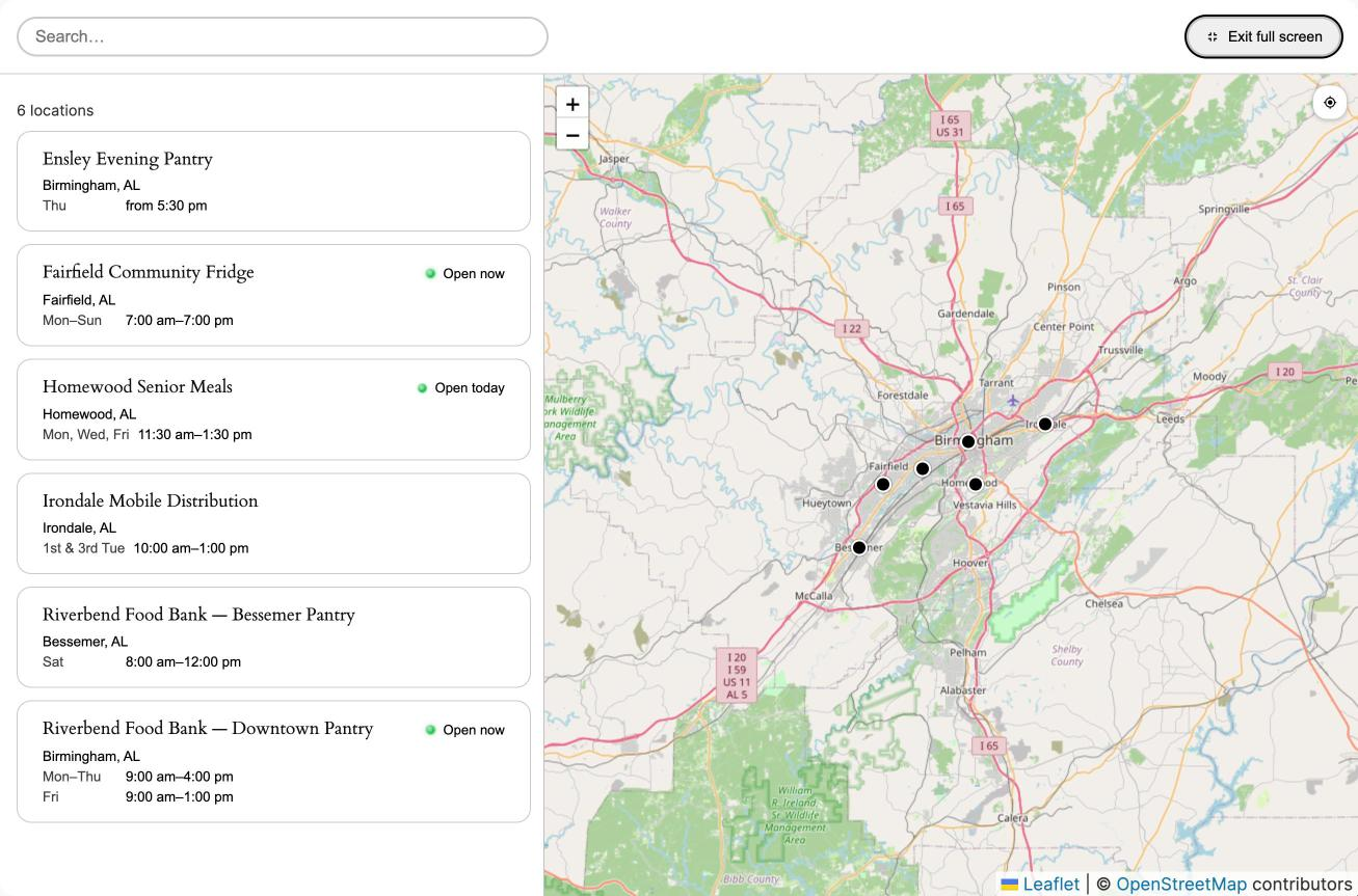
The finder on desktop — map, filters, and results side by side.
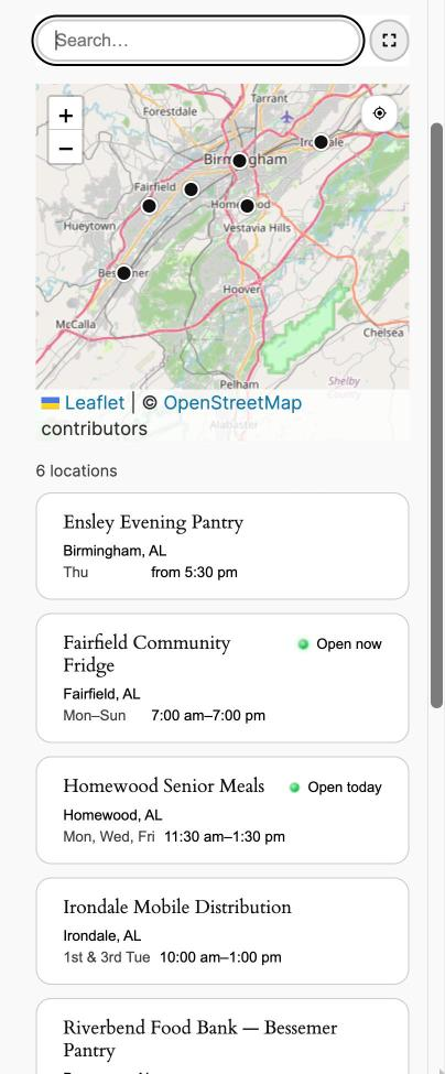
On a phone, with the map above the list.
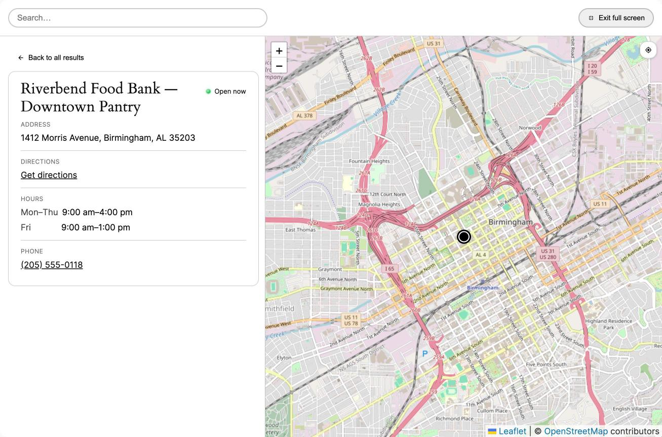
A location’s details, opened in place.
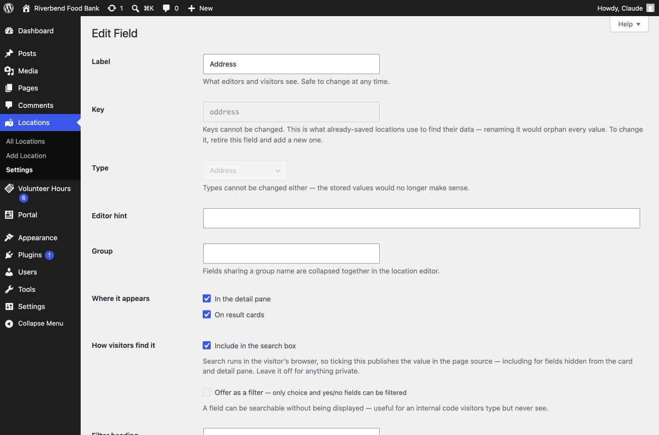
Defining a field: type, label, and where it appears.
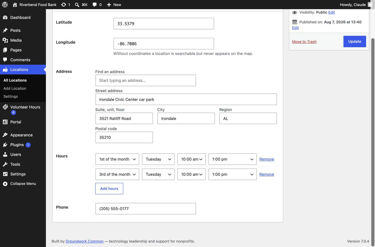
Recurring hours — “1st and 3rd Tuesday” without a plugin-specific syntax.
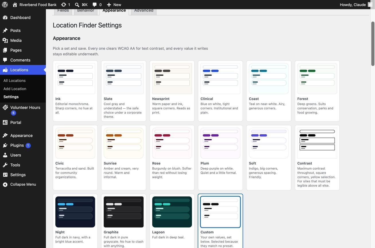
Appearance presets.