
WP Cloudmade Maps Wordpress Plugin - Rating, Reviews, Demo & Download
Plugin Description
With WP Cloudmade Maps you are able to add static and interactive maps to your website using Cloudmades designable OpenStreetMaps-Data.
This way you can add maps that fits your webdesign. Choose from over 50.000 ready-to-use map styles or create your own with the CloudMade Style Editor.
The Plugin comes with
- a widget to show your last geotagged posts with static maps,
- a shortcode for static maps
- two shortcodes for interactive maps
and countless attributes, to fit the maps your ideas.
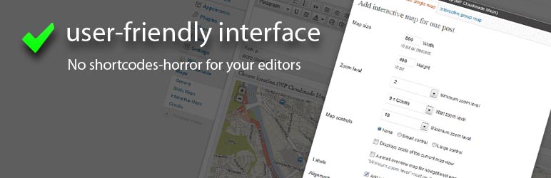
All shortcodes are accessible via an user-friendly tinymce button and a lightweight configuration interface for editors.
As Administrator you’re able to set everything as defaults, so your editor just have to ‘click & drop’ a new map inside a post, page or a custom_post_type at all.
General – Features
- add maps that go nicely with your webdesign, by choosing from over 50.000 map-styles or painting your own
- works with posts, pages and custom posttypes
- adds microformat geo-markup to your located content, to make your geo-content machine-readable
- adds meta-tags with location information to your html output, to make your website readable to geo-DBs
- ability to enable or disable unused parts of this plugin, to keep it editor-friendly
- upload custom marker images into the WordPress media-library and use it on your maps
- check all your default settings with example-maps inside the settings pages directly
- inline documentation inside the WordPress help-tabs
- complete deactivation and uninstalling routines to keep your options-table clean
- JS- and CSS files are loaded conditionally only when they are needed
Static Maps – Features
- easy embed static map images into your content using GUI or shortcode
- align maps with the default WordPress alignment CSS-classes
- add maps as background-images to the body-tag, as header-images or anywhere you want
- show posts addresses as caption of the maps with WordPress default caption markup
Active Maps for one Marker – Features
- easy embed active maps into your content using GUI or shortcode
- align maps with the default WordPress alignment CSS-classes
- add zoom controls
- show map scale
- navigate within a small overview-map
- add descriptive labels to your map-markers
Active Maps for multiple Marker – Features
This part exists, but is still in development and not really production-ready. So, it is a small window into the next releases.
- show one active map with multiple Markers, standing for posts of
- selectable categories,
- choosen tags,
- specific users,
- defined date-ranges,
- specific post-types,
- or anything else you could pick up and filter with a WP_Query request – this is the higher vision 😉
- attach Info-Window to each marker and show
the_content(),the_excerpt()or ownhtmlbased on a templatefile
Languages
- English (en_US)
- German (de_DE)
Arbitrary section
All shortcodes and its attributes are described and documented inside the WordPress “help”-tab on the upper right corner of each settings page. Have a look over there if you want to use the shortcodes in your theme files.
If you are having a feature request or bug-reports for this plugin, open an issue on github.com.
If there is nothing from you, I’ll go on doing one of the following:
roadmap
- update the help-section inside the help-tab for the enclosing variant of [cmm_active_single] and for [cmm_active_group]
- upgrading to CloudMades new “leaflet” library, when it supports the cloudmade style-ID for different map styles
- give the ability to define horizontal- and vertical-anchor for larger Marker Icons
- add an option to decide, whether to output xhtml or html markup
- add geo:RSS markup to feeds
- add an error message for non-existing default latitude and longitude in general settings
- add the ability to show the active maps with a caption of the address
- add a “show on map link”, to jump directly to a specific point
- upload an “out of range” tile image
- upload an own loading image
- enable / disable Marker clustering for active-group-maps
- upload own cluster images
- add routing between two points, your posts position and your site-visitors position for example
- remove PHP notices and warnings from the widget code
- setup a demo page with example maps
- GUI bugfix: pre-selected checkboxes could’t be de-selected by inserting via GUI
Screenshots

GUI for embedding the shortcodes user-friendly

General Settings Screen

Settings Screen for Static maps options

Settings Screen for Active maps options

“Choose Location” metabox on the Edit Screen

Map inserted in post as “user-friendly” shortcode